
Friends of Warnham Nature Reserve Response to HDC’s Revised Proposal
Slightly revised 31st October 2020 to incorporate clearer understanding of HDC’s intention to develop in the north.
Summary
HDC’s revised proposal, presented to the Friends on 12th October 2020, addresses some of our concerns for the long-term viability of Warnham Nature Reserve but falls well short of fully protecting the Reserve.
The Friends position, as described in our response to the local plan , can be summarised as:
The Reserve should be extended westwards to encompass all the northern land.
The Reserve’s extended eco-system in the south should be protected and enhanced.
Our principal concerns with the revised plan are:
HDC’s continued intention to develop north of Warnham Road
The destruction of habitats in the south, particularly the new intention to build on the land between the Red River and Boldings Brook
We are disappointed that HDC has chosen not to completely address our concerns. We now call on HDC to fully protect the Reserve by extending it to the west to encompass all the northern Rookwood land and to improve the reserve’s ecological support network in the south.
Evidence and Issues from the Presentation
HDC presented slides and answered questions that led directly to these conclusions:
Developing the Northern Land
HDC intends to develop the northern land that lies to the south of the Walnut Tree Plantation (slide 13)
Housing is shown right against the Reserve’s south western boundary (slide 13)
The workspace development in the north can include home office space, shops, community buildings and commercial / business premises. (follow up email from HDC)
Development in the north will include domestic accommodation (slide 13)
A large roundabout that destroys the Reserve’s car park and some mature trees will be constructed (answer to question)
The plans do not show any provision for car parking at the Reserve (slide 13)
Developing the Southern Land
“Fairway 15”, which lies within the Boldings Brook / Red River / Riverside Walk area will be developed for housing instead of being green space (slides 6, 13)
The Rookwood lake will be reduced to 40% of its current size (slide 13)
There is less green space in the south and many lakes have been removed (slides 6, 13)
The new bus route from Redford Avenue to Warnham Road cuts through the Riverside Walk, Red River and Boldings Brook, which the masterplan shows as being of principal ecological importance (slides 9, 11)
The virtual aerial views on slides 7 and 8 are misleading because they depict the original development shown on slide 6 and not the revised development shown on slide 13. e.g. they show lakes that are present in slide 6 but are absent from slide 13.
Protecting the Reserve
When originally created in 1987 the Reserve was much larger than today. The Reserve is best protected by extending it to the west and restoring all the northern land as green space to be shared by people and wildlife. As part of this, current habitats should be extended, and new habitats created. Development in the north threatens the Reserve by:
increasing noise
increasing night-time disturbance from lighting
predation from cats
reducing green space used by the Reserve’s wildlife for migration and foraging
HDC’s map graphic on slide 13 shows housing units immediately adjacent to the Reserve’s south western boundary without even a buffer zone. This housing is inappropriately located and should not be constructed as shown.
HDC’s proposed development in the north can include commercial / business premises, home office space, local shops, community buildings and other employment uses. This area is located adjacent to the Walnut Tree Plantation and to the Reserve’s dipping pond area. Use as proposed can generate high footfall, high vehicle traffic, daytime and night time noise as well as night-time light pollution. These activities will disturb Reserve visitors and wildlife and are inappropriate so close to the Reserve.
Domestic accommodation is shown in the north and this inevitably brings threats from day and night time noise, lighting and cat predation as described in our local plan response1. Again, this type of development is inappropriate so close to the Reserve.
HDC confirmed that they will construct a new roundabout on the Warnham Road to provide access to the northern and southern sites. Drawings provided in HDC’s local plan response show that the new roundabout will be the same size as the adjacent A24 Robin Hood Roundabout, even though it does not serve a major arterial road.
HDC accept that the new roundabout, if constructed, will destroy the current Reserve car park but the plans show no provision for a replacement car park.

Key
Red - Proposed roundabout
White - Nature reserve car park
Blue - Hub project landscaping
Roundabout outline
From HDC Transport Feasibility Report
Our preferred approach of not building in the north would mean lower traffic flows that could be managed with a smaller, different, type of junction. This would also avoid felling significant mature trees (e.g. 3 London Planes) on the golf course and adjacent Reserve car parking area.
Protecting the Reserve’s Support Eco-system
The Reserve does not exist in isolation; Rookwood Golf Course is part of its essential support network. The revised proposal shows that, overall, about 50% of the combined Reserve plus Rookwood land will be given to development, which significantly reduces the amount of green space and space devoted to lakes, e.g. at least 60% of Rookwood lake will be lost.
Wildlife uses these areas as auxiliary feeding and breeding grounds, and fairways are far from barren as stated on slide 9. This recent paper (Thomas, T. 2020) shows that golf courses are ecologically rich and valuable spaces that support a wide variety of habitats and species.
For example, the one day “Rookwood BioBlitz” in August 2020 recorded over 150 species of plants and animals in just six hours of daylight over a limited area near the Millennium Bridge on the Riverside Walk.
Arguments ascribing benefits to the development’s fragmented green space fail to consider that a collection of smaller urban green spaces does not provide the same wildlife and ecological opportunities provided by a single large green space. For this reason, both the original and particularly the revised proposal are considered damaging to the Reserve’s current ecological balance.
Of particular concern is the new intention to build on “Fairway 15” (Tulip Tree) which is in the middle of the Red River / Riverside Walk / Boldings Brook area (label 1 below). This area was originally to be retained as green recreation space but will now be built on.
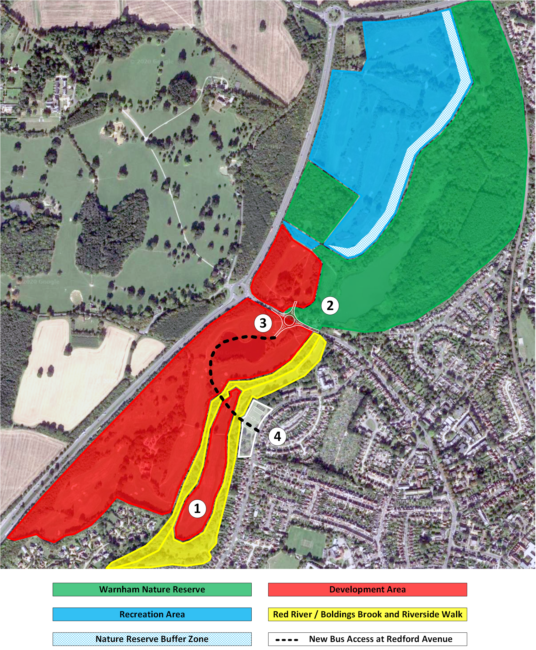
HDC’s Rookwood Ecology Constraints Plan shows that the Boldings Brook and Red River corridors are “Habitats of Principal Importance”. However, the revised proposal now builds on both sides of the Red River, and right up to the west side of the Riverside Walk and Boldings Brook. In addition, the new bus route passes across both rivers and the Riverside Walk causing further disruption to the area’s ecology.
The rivers are blue and green corridors that support the Reserve, for example, kingfishers are known to nest in the steep banks of the Red River and to hunt over the Reserve. Building as proposed will damage these areas and will consequently compromise the Reserve. It is our view that fairway 15 must be left green if HDC choose to develop the southern land.
Conclusion
We are disappointed that HDC has chosen not to completely address our concerns. We now call on HDC to fully protect the Reserve by extending it to the west to encompass all the northern Rookwood land and to improve the reserve’s ecological support network in the south.